Enterprise GIS Architect | Cloud Solution Architect | Full-Stack GIS Developer
Joseph C. Dillard
I design and modernize geospatial systems that connect Enterprise GIS platforms, spatial databases, cloud and hybrid infrastructure, data pipelines, operational maps, and AI-aware decision-support workflows.
Resume Snapshot
Architecture depth with hands-on delivery.
My background spans ArcGIS Enterprise, open-source GIS, PostgreSQL/PostGIS, Oracle Spatial, utility GIS, mission systems, Azure, Docker, data integration, GeoAI-aware workflows, and full-stack GIS application delivery.
Target Role Positioning
Best fit roles
I am targeting teams that need a senior geospatial technologist who can bridge customer discovery, architecture, infrastructure, spatial data engineering, application teams, rollout, and production support.
Enterprise GIS / ArcGIS Enterprise architecture for defense, utility, and enterprise customers
Open-source Enterprise GIS architecture with GeoServer, PostGIS, QGIS, and GIS server evaluation
Cloud and hybrid infrastructure design with Azure certification and AWS working knowledge
Full-stack GIS application delivery across APIs, web applications, spatial services, and databases
Spatial database, geospatial ETL, data readiness, and service reliability leadership
Project Stack
A connected geospatial project stack.
The public repos explain the same system thinking as my resume: how data is checked, how GeoAI output becomes GIS-ready, how PostGIS-backed layers refresh, and how map-aware assistant tools stay reviewed and explainable.
Operational map viewer and status dashboard
Geospatial Status Board
Grails and MapLibre operational map for incidents, infrastructure, GeoAI outputs, response support, weather context, MGRS, and reviewed assistant map actions.
This is the visible map review surface where gateway refresh events, GeoAI output, incident data, support lookup, and assistant actions become something an analyst can inspect.
Python-based GeoAI workflow platform
GeoAI Asset Detection Platform
Python GeoAI workflow platform for turning imagery into GIS-ready detections that can be exported, loaded, and reviewed on a map.
This is the processing layer that creates spatial intelligence before the data gateway or Status Board publishes it for operational review.
Spatial data ingestion and notification layer
Geospatial Data Gateway
.NET and Python gateway for registering datasets, tracking ingest jobs, loading accepted geospatial data, and notifying maps when layers change.
This is the handoff layer between validated files and the Status Board map, where accepted data becomes a tracked load and then a refreshable layer.
Data readiness and handoff reporting
Geospatial ETL Validation Toolkit
Python toolkit for checking GeoJSON, CSV, GeoPackage, Shapefile, and GeoTIFF inputs before PostGIS load or customer handoff.
This is the data-quality gate that catches schema, geometry, CRS, domain, and raster issues before downstream systems depend on the data.
Map-aware assistant tooling
Geospatial MCP Services
Docker-ready MCP servers that let an assistant ask controlled geospatial questions about selected map coordinates.
This is the assistant/tool layer that enriches map clicks or selected incidents without hiding where MCP ends and normal service calls begin.
Local MCP bridge and focused map demo
Map-to-AI Incident Analyst
MapLibre incident review surface for northern New Mexico with risk scoring, MGRS tools, response-support lookup, and bridge routes for assistant analysis.
This is the focused incident-analysis workflow that can be folded into the Status Board shared map and supported by the MCP services.
Architecture Views
Development and Docker views of the system.
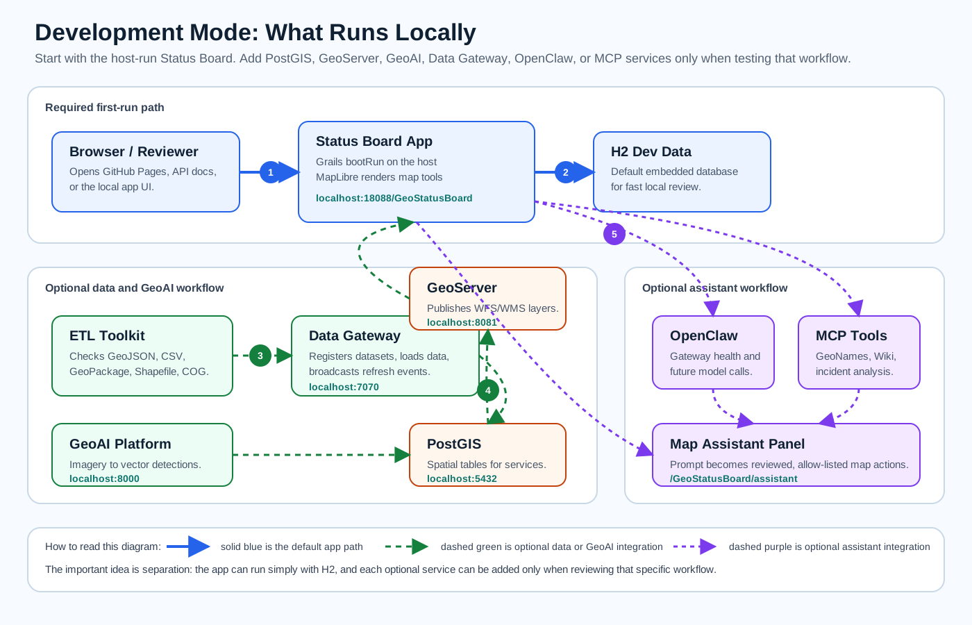
The architecture page explains what runs on the host, what is optional, which ports matter, and how data, map services, GeoAI, gateway events, and assistant tools move through the local development stack.